Snow Mountain, aka Xueshan (雪山), which stands at an altitude of 3886m, is Taiwan's second highest peak. It is located along the Snow Mountain Range (雪山山脈) which stretches from the north county of Yilan (宜蘭) to the central county of Nantou (南投). Xueshan is part of the Shei-Pa National Park (雪霸國家公園) and to get there, you will need to reach Wuling Farm (武陵農場) which is the start point of the trek. The entire trek takes a total of 3 days with the 1st day mainly on getting there. The 2nd and 3rd day is where the long hours of trekking are and taking on the summit. .
 |
| Sunset at Danshui |
After 6 months from my previous trek on Yushan, I am back in Taiwan for my second trek on Taiwan’s second highest peak, Xueshan (雪山). It was end October 2006; the weather was cooling at an average of 22 degree celsius in Taipei. The weather was quite abrupt with some days cloudy while others were clear blue skies. We had a few days of fun at Taipei, Danshui (淡水), and LeeFoo Theme Park Village before our trek.
On Day 1, our mountain guide friend came on time at 9am at the Taipei Railway Station to pick us up for the drive from to Wuling Farm. The day started off with really bad weather. The Taipei skies were darkened with heavy clouds and rain was falling with string winds. But the good news from our guide was that the weather in the central region of Taiwan was reported to be clear skies and sunny. I was quite skeptical about his comments but it was later convinced when we arrived at Wuling Farm. After leaving Taipei, we were on the highway towards Yilan through the newly opened Snow Mountain Tunnel (雪山隧道). This tunnel is the longest dual passageway tunnel in Asia, and it stretches for a total of 12.9km. With speed restriction on vehicles at 60km/h, clearing the tunnel took us approx 20mins. At around 11am, we reached Yilan City (宜蘭市) and on our way on highway 7 towards LiShan (利山). We can feel the temperature going down as we drive into the mountains. Around 2pm, we reached Wuling Farm where we stopped for lunch.
 |
| Sea of lavender at Snow Mountain Park |
 |
| Lavenders in bloom |
There were patios and patios of lavender decorating the driveway to the visitor centre as we drove past them. The weather has cleared up and there were lots of radiation from the sun’s rays. This was much preferred than the cloudy and wet weather in Taipei. It was a weekday and there were still tour buses parked at the visitor centre.
 |
| Great weather at the National Park |
 |
| Carpark area if the Park HQ |
After our lunch, we drove further into the Wuling Farm to the Snow Mountain Administration Office at the farthest end of the road. The office (see above) is located on the slopes of the mountain, over looking the opposite mountain range. The view was really breathtaking. You could see the clouds pouring down on the mountain and the evening sun (around 5pm) casting a shadow of the mountain behind us on the opposite mountain.
 |
| Reporting station for the climb (watch a video) |
 |
| Afternoon view at the trailhead (reporting station) |
On Day 1, after discussing with some other trekkers, some have opted to take the quick approach to reach the summit. The approach was to dump all the heavy backpacks (food esp.) at Chika, and make a fast and lightly loaded accent to the summit. This will take less time without the load and make it back to Chika by nightfall. The original plan was to rest the night at the 369 mountain lodge which is the lodge closest to the summit. The reason to take the alternate approach was to overcome the steep and tough trek between Chika and 369 lodge. Doing a round trip from 369 to the summit requires about 3 hours. Hence we took the alternate approach and started our day 2 trek with a light load.
At 3am, we moved off from the Chika lodge and made our way through the forested trail behind the lodge. It was pitch dark and headlights or any torchlight is a must to trek at this time of the morning. The trail started off gentle and as we moved higher, the trail became much rocky with loose rocks. As we came out of the forested trail, we came to a clearing and we can clearly see the opposite mountains that we saw at the trailhead. Little sparkle of orange street lights came from the Wuling Farm below us. A check on my altimeter watch showed 2700m. There was a viewing platform at the clearly where we can see the skies starting to brighten up. The layers of cloud seemed motionless, sitting on the peaks of the mountains.
 |
| Sunrise while on the trail |
 |
| Morning sea of clouds |
 |
| Here the sun rises from the clouds |
After a quick break and some light snacks, we were on our way up the steep slopes of the trail. This is the part of the trail where they named it 哭坡。After overcoming this leg of the trail, one can understand the strenuous effort to the extent that you can cry over it.
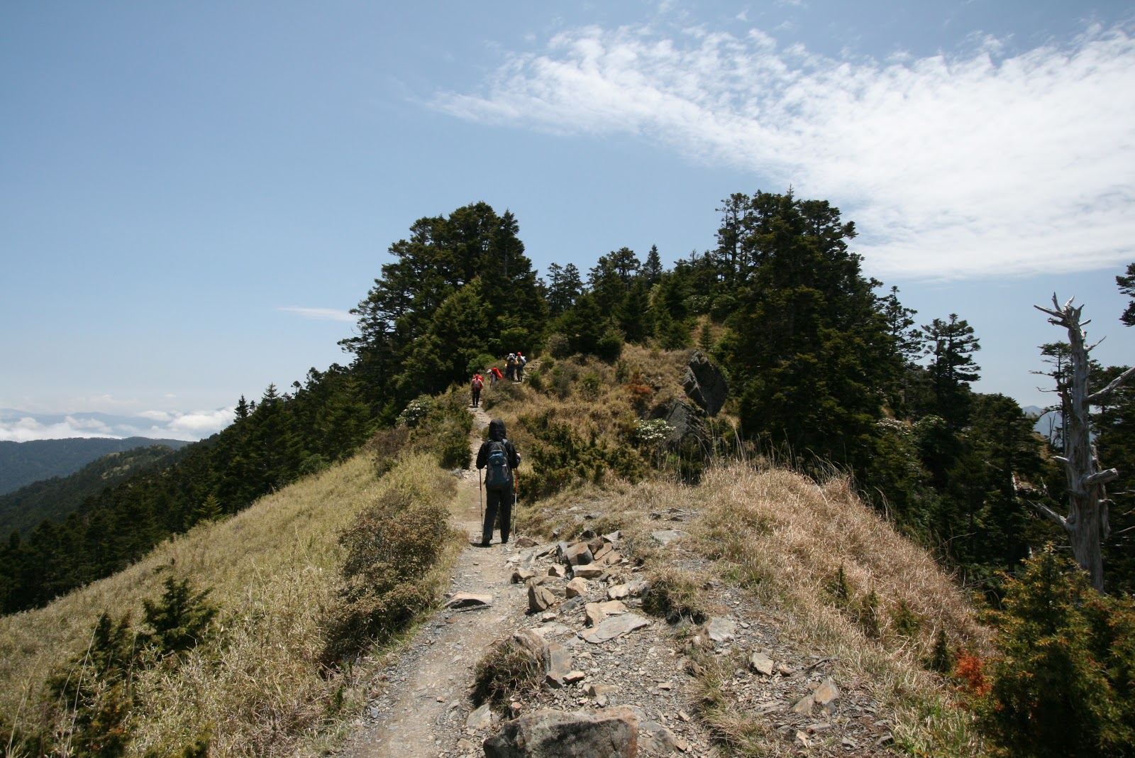
The trail after哭坡 was less strenuous, but there were still some roller-coaster trails for us to clear. The trail at the point was narrow as it run along the ridgeline. We can see both sides of the slope as we tracked carefully with our hiking sticks along the ridgeline. After another 2 hours, we reach our first peak. The XueShan East peak (雪山東峰, 3150m). The weather was great and we could see all the distant mountains that surrounded the spot where we stood on. The sun was a great welcome as we warmed ourselves by doing a bit of sun tanning.

 |
| At the Snow Mountain East Peak |
After some photo shots, we made our way down the hill towards the 2nd mountain lodge 369. The trail from the eastern peak to 369 lodge was downhill and gentle all the way. The lodge was located at a lower altitude than the XueShan East Peak.
 |
| On the trail to the lodge 369 |
 |
| Remnants of previous forest fires. |
As we got closer to 369 lodge, there were some interesting ‘white trees’. Did hear about some fires many years back that created some phenomenon. Just behind the lodge, there were some trees already in dull red color, readying themselves for the coming winter. It took an hour from arrived at lodge 369 from the eastern peak. The lodge was quite empty except for loads of backpacks stack in the bunks. Many of the trekkers have made off for the summit for view the sunrise. They must have rested for the night at the 369 lodge prior to the ascent to the summit. We took our light meals at the lodge before setting off for the summit. Taking the zigzag trail behind the lodge, we made our way to the black forest (黑深林). Once we entered the black forest, we can felt the temperature dropped because of the lack of sunlight due to the thick canopy of the forest. There were lots of dead fall, fallen trunks were laid across the slopes of the forest. After making through a few hundred meters into the forest, we and our mountain guide friend decided it may not be wise to carry on because of the change in weather and the amount of time left to get to the summit and make our way back to the Chika Lodge. Because we chose the alternate approach in reaching the summit with light load, we left our sleeping gears back at Chika lodge. If we push on towards the summit, we may be making our way back to Chika in the dark. A decision was made to head back. We were so close to the summit, yet we have no choice but to make our way back to Chika Lodge. If we had followed the initial plan and sleep for the night at 369 lodge with all equipment. We can make it to the summit and make our way back to the trailhead all in one day. As our guide told us, “The mountain is always there, you can come back again”.
The descent was a quick one, our pace of footsteps increased as we made our way back to Chika Lodge. When we reached the viewing platform after descending from KuPo (哭坡), I took a photograph of the other trekkers making their way down.
 |
| Groups of hikers descending the 哭坡 |
 |
| Snow Mountain Peak? |
We rested for the 2nd night at Chika Lodge before making our way back to the trai lhead on day 3 morning. Our mountain guide friend gave us a ride to Taichung which was our next destination for our trip. I believed there will be a time when I will come again and put my trekking shoes on Snow mountain again.
If you are interested in Snow mountain and planning to get your friends for this trek. Just drop me a mail, I can help you make the arrangement with my mountain guide friend. Maybe I will join in as well.
2nd Climb on Snow Mountain (2009)
We came back to scale snow mountain with a group of friends this time round around Nov 2009. Weather was bad for the start from the trail head to the first lodge of Chika. Luckily the initial day's walk was just 2 hours from the trail head to the Chika Lodge where we spent the night since it was already afternoon time when we departed from Taipei in the morning.
 |
| Rain & Mist all around |
 |
| At the Chika Lodge |
 |
| Chika Lodge |
It was a hot soup and rice for dinner before the night's rest.
 |
| Next morning climb. Misty and windy (less the rain) |
The next morning, the rain has stopped but it was still very misty and windy. Nothing much to see, no views. Just walking in the fog. The trail was wet due to the heavy morning mist, but the air cool and fresh, good for the lungs when doing such exercise. When we reached the steep KuPo (哭坡), the wind was very strong. There is a big resting platform for hikers to enjoy the mountain range view, but there was no view at that time. Still we rested a while there but couldn't stay too long as it was freezing cold because of the strong wind.
 |
| At the Snow Mountain East Summit(Bags all around) |
|
|
|
 |
| At the summit (east peak) |
 |
| Path that continues on to Lodge 369 |
After clearing the KuPo, it was only a short hike up another trail that we reached the East Peak of Snow Mountain. Bags off was the first thing and everyone went to take picture with the signage of the summit. The weather has cleared up a bit. no more strong winds, except that we were still surrounded by thick clouds. There was some short duration of the sun breaking through the clouds. From here it was downhill all the way to lodge 369. Come to think of it, shouldn't be going higher and higher? Lodge 369 is located at a lower altitude than the east peak. It was a easy hike through the forest area again and once we emerged from it, we could see the lodge 369 just a short distance away.
 |
| SanLiuJiu (369) Lodge |
 |
| All about 369 cabin |
It was still cloudy but the weather was calm and cooling. It was about lunch time (12noon) that we reached the cabin, we quick meal from our dried foodstuff and off to the bunks to rest since there was nothing else to do. The guide did ask if we want to go for the summit since we had so much of time. A round trip to the summit and back could be 4~5 hrs. But with the dark clouds above and did not think there was much to see, we preferred the original plan and waited for the next morning summit challenge.
 |
| Cold and freezing. All wrapped up |
 |
| Sky clearing up during dinner time |
 |
| 369 cabin |
The cabin itself, I could only say it was not very well maintained. There wasn't a caretaker like the over popular Paiyun cabin (Mt Yushan trek) and the interior does need a makeover. Luckily it was not peak season and we were the only group in the cabin. Over at evening time a few more small groups came.
The next morning, we started the hike at about 3am, walking through the mysterious Black forest. There were incidents of hikers getting lost in the past, but not the path is more well fence up so that hikers don't take the wrong path at night. Why it was called black forest was because of the dense forest vegetation and it canopy blocked out much light from the skies. Well i would say it may be some exaggeration over the description. The climb was steep and at times some members need to slow down to rest a bit. In the end, we missed the sunrise at the summit, but we were able to see the golden yellow sunrise painting the mountain valleys. The sight was warming and comforting even though we were not at the top.
 |
| Sunrise in the mountains |
 |
| Valley in sunrise lighting. Summit on the left |
 |
| Taking the trail to the summit |
The open area was vast and view was stunning. It was like we were surrounded by a wall of mountains and it made us feel so small and insignificant. The trail on the left started to climb and lead to the summit. The trail actually goes up a rather difficult slope to the ridge line of the mountain top where the summit point lies.
 |
| Nearing the top ? Not yet |
 |
| The trail we took. |
 |
| Walking along ridge line |
As we near the top, there were more of broken rock piece similar to those that could be found in Yushan. Small little rock plates. Surprisingly there were little alpine shrubs that could within the cold up at that altitude.
Finally, the summit of the Snow Mountain (Syue Mountain).
Weather may not be the best but it was good enough for us. We could see the clear blue skies above, and ocassionally clouds came and covered us momentarily. There seemed to be a narrow passage for the clouds to come from once side of the ridge and got vapourised once they cross over.
 |
| Holy O trail, Ridge line trekking |
There was a signboard explaining the ridge line trek from Snow Mountain all the way to DaBaJianShan. It was just our group at the summit, meaning no one came to see the sunrise on time. My guess was to see the sunrise, one has to start the climb earlier from 369 cabin
 |
| Another group just arrived at the summit. Brewing coffee |
From here it was all the way back to 369 cabin and to Chika before the car park for the drive back to Taipei where the yummy food was waiting for us.
The black forest when appeared in daylight look inviting and cooling, being the only place to give us shade from the sun ever since it came out in full as we started the descent.
 |
| Walking thru the Black Forest |
 |
| Some directional sign boards |
Descending is always much faster and the skies was clearing quite fast. The area between the 369 cabin and the forest entrance was quite bare. There was a big fire recently during our climb and the fire came very close to the 369 cabin. Remants of the forest fire still could be seen here.
 |
| Burned line where the fire was. |
 |
| 369 cabin in sight after leaving the Black Forest |
From the cabin, we packed up our sleeping bags and backpacks and started the hike back to teh trail head. The sun was coming out in full force and halfway through we were sweating and not longer feel cold. Under the sun it was warm, under the shade of a tree and it was chilly. What a nice way to warm and cool down.
 |
| On the ridgeline towards KuPo |
 |
| Smaller sea of clouds just crossing the mountain range |
Somewhere around 2pm, we reached the carpark and started the long drive alogn the east coast via the town of Yilan, going through the Snow Mountain tunnel and in no time, back in the city of delicious food and nite markets. I don't think I have to say where we went after there.
 Continues from Part 1....